Цей запис також доступний українською.
Last year, the Kharkiv region was one of those parts of Ukraine that suffered the most from Russian shelling and active hostilities. Small and large cities, villages, fields and nature reserves — Russian aggression has left the mark of its crimes everywhere.
Ukrainian civil society, international partners, and the state have already begun active work on assessing the consequences of these destructions, and in some cases, their elimination. Economists and analysts are calculating damages in order to file a claim for reparations; human rights defenders are recording war crimes in order to bring the perpetrators to justice; the state engages international experts to assess infrastructure losses, etc. However, it is also important to understand the consequences that these damages will have for the environment of the region. And this is no easy task.
Assessment of the effects of the war on the environment requires specific knowledge about the region and its landscape, as well as technologies that can collect the greatest array of data without risking researchers (after all, conducting fieldwork in those places is still dangerous due to the risk of encountering an unexploded shell or mine). Here is where geographic information systems (GIS) — modern computer technology that can combine a model image of the territory with various types of data and explore dangerous areas without risk — can come in handy.
Sounds complicated? Then let us explain how it works, using the example of the project of Environmental Geoinformation Systems of Ukraine NGO, which received support from our Foundation’s Environmental Initiative (EPAIU) as part of the grant competition “Supporting Environmental Public Initiatives from the Southeastern Regions of Ukraine During the War” funded by Sweden.
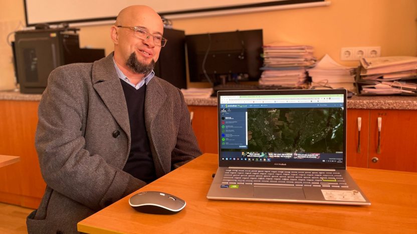
The NGO’s team, which consists of biologists, geographers and environmental experts from various universities and environmental protection institutions of the country, uses space images and geographic information technologies (GIS) to determine the damage to natural systems and their individual parts in the Kharkiv region as a result of hostilities in 2022.
“Working with geospatial data now is like working with a navigator. It used to be something complicated that required very specific skills, but today it is a useful and relatively easy-to-learn resource that has many applications. Our project showcases just one of many possibilities,” said Dmytro Diadin, Head of the Department of Urban Engineering Ecology of Beketov Kharkiv National University of Urban Economy, researcher of the project.
The damages recorded by scientists occurred as a result of shelling, construction of military fortifications and fighting in the period from February to October 2022 (the time of active hostilities in the Kharkiv region). With the help of publicly available satellite images, they find points of damage and projectile craters, establish their size, location and causes. Visual decoding of the data obtained from the images is done manually.
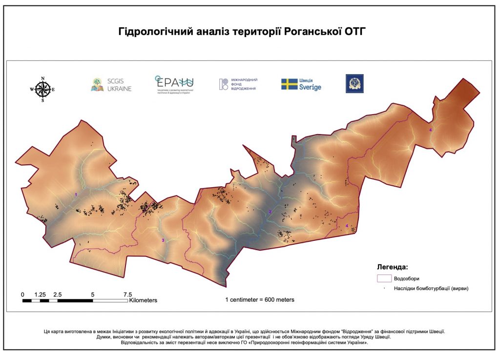
In total, researchers have recorded more than 60,000 such points in the region and are gradually processing the received data. For example, on the territory of the Rohan municipality of the Kharkiv region, 916 explosion craters have already been recorded. Most of them were dated March 2022. All craters were also classified into three groups: large, medium and small.
“The size of the crater directly depends on the type of projectile that created it. Large ones are, most likely, direct missile hits. Medium and small craters are created by cluster munitions. But it is difficult to fix the craters, especially during the period of early spring, when the soil is wet. Difficulties also arise due to the weather, as sometimes the images are indecipherable due to cloudiness,” explains Professor Andrii Achasov, member of the NGO’s team, Acting Head of the Department of Ecology and Environmental Management of the Kharkiv University.

However, the researchers did not stop there. Based on data on the size, depth and cause of soil damage, they build models of potential pollution, as each projectile contains many dangerous heavy metals and organic substances, the concentration of which depends on its type and size.
One of the questions that residents of the Kharkiv region had worried us too: Could these data help the enemy if they dare to attack the region again? Dmytro Diadin gave the answer to that. “We consulted with representatives of the State Bureau of Investigation regarding these data, whether they should be published or not,” he said. “The answer was obvious. It’s one thing to process these data, and another to publish hit coordinates, etc. Therefore, we have prepared infomaps that illustrate the problem without exposing sensitive data.”
For instance, they create maps that show damaged areas and pollution halos. The team has already developed several such maps for the Rohan municipality.
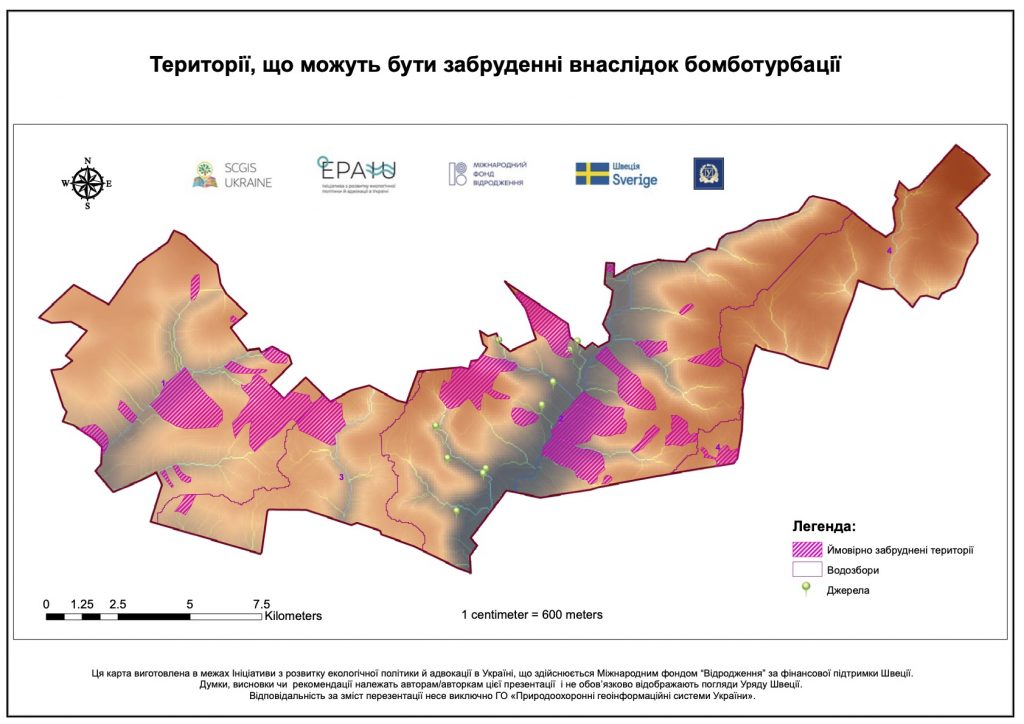
The maps show the most affected areas and allow for a quick assessment of which agricultural fields and other areas need attention first. In addition, they show areas that are still dangerous due to unexploded ordnance or contamination with heavy metals and organic substances remaining in the soil after the explosion. This will help to assess the most dangerous areas in terms of explosive hazards. According to the statistics based on the surveys of post-war landscapes, the amount of unexploded ordnance can reach 50%. Such information can be used even now to prevent possible injuries to people and to plan demining.
“Our project is not only about recording direct damage from shelling. It goals also include an assessment of what and how was affected: soils, plants, animals, entire ecosystems and natural areas. And, importantly, it will help to plan recovery efforts for these areas,” said Andrii Achasov.
The project team will also conduct a biodiversity risk assessment and attempt to assess changes in ecosystems retrospectively, based on old photographs. As part of the project, scientists are preparing expert recommendations on the further use of damaged natural areas for managers and recovery professionals in the municipalities of the Kharkiv region. According to the team, there is a demand for such research and recommendations, and not only in the Kharkiv region. For example, sappers in the Mykolaiv region have already requested the organisation to do the same research in their area.
The Kharkiv Regional Military Administration recently announced the creation of a working group to collect information on environmental damage in the region. It will include heads of district military administrations, invited heads of state environmental protection and control bodies, scientists and the public. This is an important start of the recovery process, and we hope that the team of Environmental Geoinformation Systems of Ukraine will be involved in these efforts and in the search for sustainable and environmentally friendly solutions.
If you are interested in the topic and methods of using GIS, please join the thematic seminars held by Andrii Achasov, Acting Head of the Department of Ecology and Environmental Management of the Kharkiv University.